When location matters in the every day life of the Danube region countries
Join the second Danube Open (Geo) Data, Citizens Science & INSPIRE Hackathon
in Bratislava, Slovakia
Date of the event: 12th - 13th of December 2016
Venue: ImpacHub Bratislava
Big thanks to all!

Photo gallery of the event.
Explore Your Urban Environment [1st place]
Team: Karin Wannemacher
Description:
Explore nature within your city with treasure hunts based on open environmental dataUsed data resources:
Used technologies: jqueryMobile, Leaflet, PostgreSQL
Additional info:
Team: Josip Lisjak; Saša Vranić; Hrvoje Tomić; Tomáš Kliment
Description:
App enables owners of orchards and vineyards to give the location of pruned branches in order for biomass producers to pick up the branch pileUsed data resources:
Used technologies: OpenLayers, Geoserver, PostgreSQL, HTML5, jQuery, Bootstrap
Additional info:
Team: Gergely Padányi-Gulyás
Web app providing an access to the visualisation and basic calculation on top of Copernicus data
Used data resources: SK, HU Copernicus data
Used technologies: MANGOL web mapping GUI framework
Additional info:
Team: Jakub Kočica, Tomáš Kliment
The aim was to publish and share data from Sentinel II mission and basic derivates from this data. We use Level 1C (georeferenced) imagery which covers the area of Slovakia. Final dataset should be accessible trough WMS and WCS
Used data resources: SK Copernicus open data from ESA´s Sentinel 2 mission
Used technologies: Geoserver
Additional info:
Team: Kathi Schleidt, Tomas Kliment, Christoph Fink
Project aims to define a method for visualization of complex INSPIRE Features
Additional info:
Team: Roman Pickl
Integrated Mobility in Urban Areas of the Danube Region(https://www.fluidtime.com/de/fluidhub).
Used data resources: Data from Mobility providers (OpenData, OpenAPIs, commercial APIs, Information from Websites), sdi4Apps (especially Parking), Google APIs
Used technologies: https://www.fluidtime.com/en/fluidhub
Additional info:
Team: Dmitri, Pavel, Andrea
Developing documentation and examples to SDI4Apps platform
Additional info:
Team: Pavol Goliaš,Karol Bujaček,Jozef Szadvári,Tomáš Matula,László Nagy,Andrej Ďumbala
Our project is based on GeoData for JIRA extension. This addon is currently used in New Town district in Bratislava to collect requests and suggestions
Used data resources: Issue data from Bratislava New Town citizens
Used technologies: JIRA
Additional info:
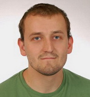
Team: Jan Zacharias, Boris Kruzliak, Jachym Cepicky, Tomas Kliment
The main goal of the project was to visualise the quality of land use HILUCS categories provided by the SDI4Apps Open Land Use dataset
Used data resources:
Used technologies: QGIS, Postgres DBMS, Geoserver WMS, WFS, WPS, Leaflet mapping JS library
Additional info:
After the initial experience from DanubeHack 2015, we believe it still make sense to create the space, where where people can present what can be done with the open (where relevant geo) data resources, technologies and share ideas, experience and knowledge. With that in mind, DanubeHack 2.0 aims to:
To proof that there is potential, present what’s behind you and your mates! Identify the possibilities, pitch ideas, promote your data, re-use available open data & software technologies to create new data, software, apps, or visualisations! And last but not least meet new people and spent two days in Bratislava close to the Danube river.
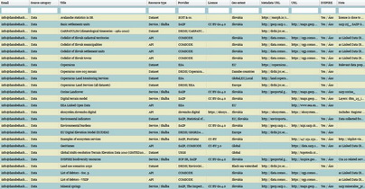
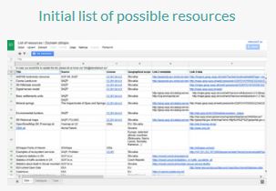
Initial list of application domains:


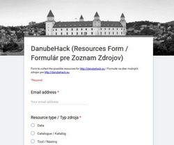
In order to support the participants of the event, Initial list of possible resources has been made available.
The list is accessible via:
| Simple search list | G-Doc Table |
 |
 |

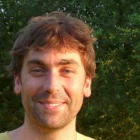
Jáchym is a developer specialized on map apps and the original author of PyWPS project. He contributes to many opensource projects and is a founding member of OSGeo.cz and a member of Open Source Geospatial Foundation. He works as a (Geo)Python trainer at GISMentors and a technical consultant at Cleerio.


In his professional life, Dirk is founder and CEO of Geosparc. He has extensive software development experience as a developer, architect, project manager and has been involved with the development and implementation of numerous IT infrastructures using a variety of technologies on multiple platforms. Dirk is is a member of the advisory board of the Industrial Industry Fund (university of Ghent) and part of the "geospatial datainfrastructure" (GDI) advisory board of Flanders. Dirk is an OSGeo member since 2007, became a charter member in 2013 and is since January 2016 vice president of OSGeo.
Tomáš is a researcher who has been working in several European, regional and local projects focusing on geospatial resources discovery, management and sharing with main focus on data and metadata workflows automation. He recently finished the postdoctoral position funded by the NEWFELPRO program implementing Bolegweb project.
https://www.researchgate.net

Alex is expert in geospatial data management and interoperability. He currently works at the EC Joint Research Centre.
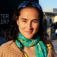
Codrina is a technical geographer, an open source GIS user, with research interests in data interoperability in hydrogeology, an active advocate and supporter for the open data initiative. Looking into data policies, as well.
Olav Peeters develops and maintains the spatial data infrastructure of the Belgian Interregional Environment Agency (IRCEL-CELINE) including public (real-time) data endpoints, clients for analysing and visualising the data and e-reporting of air quality data. He is also involved in the development of hi-resolution air quality models (RIO-IFDM) and implementing (new) air quality measuring techniques (low cost sensors, woodburn, quality assessment/control).
Sven is a geospatial information scientists specialised in the integration of data from multiple sources. He works at the European Commission's Joint Research Centre (JRC).
Kathi is a specialist for the provision of observational and measurement data within INSPIRE. She coordinated the guidelines for the provision of O&M data in INSPIRE, and developed the European Air Quality reporting data models. She has now founded a startup datacove.eu.

Brooke is a remote sensing scientist turned entrepreneur and drone pilot. She specialises is remotely sensed & GIS data for policy surrport and community development. She currently provides support to various European Commission projects.
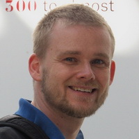
Martin is supporter of geospatial information use, focusing on spatial data infrastructures & eGovenment aspects.
It’s not about winning - it’s about learning and making contacts, friends and networks (so everyone’s a winner!).
A panel of skilled judges will select the best outcomes.
Awards list:
1.Place: 1500€, Airport UAV pack, WebSupport Virtual server V2 for 1 year
2.Place: 1000€, Airport UAV pack, WebSupport The Hosting for 1 year max. size 3GB
3.Place: 500€, Airport UAV pack,WebSupport The Hosting for 1 year max. size 3GB
INSPIRE Award: Lenovo Yoga Tablet 2 10 LTE 32GB Ebony + cover with keyboard
Awards have been supported by:
EC JRC, EEA foundation, E-Pro, HERE, ProNatur, SAŽP, WebSupport
This single sessions hackathon event will be combined with the set of Lightning talks addressing various topics. DanubeHack 2.0 will provide the space as for developing new apps, services and data as well as session offering knowledge sharing via workshops, including the provision of space for discussions on relevant topics.
Warm up, by presenting the aim of the event, input data and technology as well as participants. Pitching the ideas into the projects and setting up the project teams, side activities, midhack.
Day 1 follow up, presentation of the projects outcomes, evaluation and awarding of the best ones and the outlook for the future possible activities.
Indicative programme
| Day/Deň | Time/Čas | Hackathon | Author/s | Language/Jazyk |
|
Day 1 Thursday |
08:30 | Registration | EN/SK | |
| 09:00 |
Invitation and introduction of the event |
Alexander Kotsev, Martin Tuchyňa |
EN | |
| 09:30 | Data intro (flash presentations) | EN | ||
| 10:00 | Pitching/Collection of the project ideas - 2 mins/per person. Elevator pitches,no slides. | EN/SK | ||
| 11:00 | Coffee break and creating the teams | EN | ||
| 11:30 |
Hacking & Lightning talks |
|||
| Price of open source with my gives and takes, while working on open source software | Jáchym Čepický |
EN | ||
| EU Data Sources | Kathi Schleidt | EN | ||
| Open Geo Data and IoT Revolution | Aleksander Kotsev | EN | ||
| Open geo data endpoints of air quality data in Belgium | Olav Peeters | EN | ||
| SDI4Apps - An Instrument for Unleashing Open Geographic Information | Dmitrii Kozhukh | EN | ||
| 13:00 | Lunch break |
|||
| 14:00 |
Hacking & Lightning talks |
|||
| Open Data @ SK Open Government Partnership | Milan Andrejkovič, Iveta Ferčíková | |||
| Open community made by Slovensko.digital | Lubor Illek, Jan Suchal | |
||
| Towards Standardization of Slovak Linked Geo Data | Miroslav Líška | EN | ||
| Open INSPIRE made in Czecho&Slovakia | Jitka Faugnerova, Martin Tuchyňa | EN | ||
| 15:30 | Coffee break | |||
| 18:00 | MidHack - presenting the achievements and problems teams are facing (3-5 mins each!) | EN/SK | ||
| 20:00 | End of day 1 |
|||
|
Day 2 Tuesday |
08:00 |
Hacking |
||
| 11:00 | Coffee break |
|||
|
11:30
|
Hacking & Lightning talks | |||
| Power of open source, Business perception | Dirk Frigne | EN | ||
| Potential of UAVs (Drones as a data source) | Brooke Tapsall | EN | ||
| Citizen Science in relation to open data (gathering and use) | Sven Schade | EN | ||
| Promoting the free sharing of geospatial knowledge | Codrina Maria Ilie |
EN | ||
| 13:00 | Lunch | |||
| 14:00 | Hacking & Final presentation flash training for hack team leaders | EN | ||
| 15:30 | Coffe break | |||
|
Hacking |
||||
| 16:30 | Final presentations | EN/SK | ||
| 17:30 | Anouncing and awarding the winners | EN | ||
| 18:00 | Conclusions and acknowledgements | EN | ||
DanubeHack 2.0 is the second edition of the Hackathon organised in Bratislava (Slovakia) as follow up of the DanubeHack taking place in 2015. Main aim of the DanubeHack 2.0 is to create the space, where those with the interest in potential of Open (Geo) Data can meet, present their ideas, knowledge a discuss the possible ways of further cooperation or project ideas.
Danube hack will last 2 days, starting on the Monday morning (12th of December 2016) and will last till Tuesday evening (13th of December 2016). For more detailed roadmap and updates in agenda, check regularly this website.
Any enthusiasts willing to show, what can be done with available data and technologies as well as anybody with the interest in improvement or sharing the knowledge with related topics are more than welcome. The same applies for those willing to present available Open Data. Anyway, because of capacity limitations, organisers will evaluate the registration proposals in order to cover thematic and geographical scope of the event.
Main motivation to consider your participation should be the willingness to explore or demonstrate the potential of the Open (Geo) Data added value as well as share and collect related information, knowledge and experience. Data produces can also advertise their Open Data and get direct feedback from their users. Geo data by its nature provides spatial delineation for any phenomena we are facing these days. Therefore, despite the primary geodata focus any non - spatial data which can have direct on indirect linkage to location and space will be in scope, independently of their origin. The same will be applied for technology part of the event, where any perspective software platforms, solutions as well as approaches and methodologies will be more than welcome. Initial List of resources (covering identified data, catalogues and related tools) has been made available and will be updated by the organizers, supporters including input received from you. Registration was possible via registration form.
Hackathon will be primarily focused on implementation of the ideas presented and supported by the teams created from the participants at the beginning. Lightning talks will provide the small enrichment of the event with the short inspirative contributions for the relevant topics.
The success and quality of the event is closely linked with the received support and sponsoring. Event can provide unique opportunity to trigger promising ideas, gain new knowledge or uncover smart experts. Therefore, various modules of event supporters/sponsors have been identified:
Participation is free of charge, based on the registration. Because of the capacity limitations, organisers will evaluate the registration proposals in order to cover thematic and geographical scope of the event. Selected participants will be contacted with further details.
Watch this space regularly, or follow the latest updates via Facebook .
To provide the support for the hackathon participants, group of mentors with expertise from wide set of domains will be on place to provide the guidance, where needed. Evaluation of the outcomes from the projects established during the hackathon will be undertaken by the panel of skilled judges.
There will be prepared essential set of foods and drinks for the whole event, including connection to the electric and internet networks. Hackathon participants shall bring their tools and enthusiasm.
No. When the Hackathon kicks off, you’ll have the chance to pitch your idea to all participants, or to join a team you find interesting. Teams may combine or split up according to their interests and goals.
Hackathon will take place in ImpactHub located in the Bratislava centre. Transport options:
List of those who helped to make this event happened.....
If you would like to support and sponsor this event, please get in touch with us.
For further information, recommendations and support, please use this form, or send us an email: